12MAC 2014 - NOSTALGIK ketika berada secara Life di SINI..TIPS of BoRNEO ..Rasa AWESOME dapat menjejak kaki di sini..Macam mimpi aje ya... SUBHANALLAH..sungguh indah panorama di sini..
 | ||
| Rakaman Gambarfoto sendiri....perlu bagi kredit juga pada diri sendiri.. walaupun tak profesional...but .. | It Really Means EVERYTHING.... |

 |
| Bukti berada di sini yaa...Tourist mat salleh di belakang tu.. |

 |
| Gambarfotoku - Air tanganku..ok kut... |
Rujukan internet...
Tanjung Simpang Mengayau
From Wikipedia, the free encyclopedia
This area marks the northernmost tip of Borneo island.
History
The original name of Tanjung Sampang Mangazou comes from the language of the Rungus, an ethnic group which resides mainly in the district of Kudat. The words Tanjung (cape), Sampang (union) and Mangazou (battle) refers to this location of a battle that occurred when the ethnic Rungus defended their territory against the attack from Moro Pirates.[1][2] According to legend, this place was a favourite landing point for the pirates.[2] While the Chinese people call this place as Foh Liew, which in Hakka means lighthouse due to a lighthouse on a nearby island of Pulau Kalampunian can be seen from here.During the famous circumnavigation era, Ferdinand Magellan fleet supposedly went here to perform repairs on his ships.[1][2]
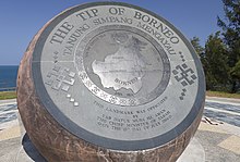
Bronze globe

The bronze globe.
|
|
| Coordinates | 7°02′14″N 116°44′32″ECoordinates: 7°02′14″N 116°44′32″E |
|---|---|
| Location | Kudat |
| Dedicated to | Marks the northernmost point of Borneo island. |
References
- ena (9 July 2012). "Heaven at the edge of Borneo". Tourism Malaysia. Retrieved 22 March 2014.
| ||
The Tip of Borneo - Tanjung Simpang Mengayau
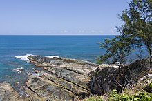
This dramatic headland is situated in the northern-most tip of BORNEO, the third largest island in the world,
after Greenland and New Guinea. It is located in the Kudat Peninsula,
about three and a half hours (or 215 kilometres) drive from Kota
Kinabalu City.
Simpang Mengayau means 'lingering junction' as it is here that the South China Sea lingers and meets the Sulu Seas flowing from the east ... Enjoy the stunning view. The sunsets and full moons are just beautiful ... The Pulau Kalampunian lighthouse is a reminder of treacherous coastline and past shipwrecks. On the left is the beautiful beach of Pantai Kalampunian.
It's a lovely easy stroll to the flagpole, the Glob


No comments:
Post a Comment